
|
|
Brittany and Finistere coast |
![]()
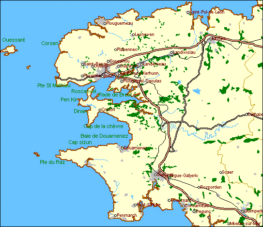

True breakwater of France, Finistere matches between the Channel et the Ocean a covered distance of more than 600 kilometers of coasts that are between the most wild, the most raised pitfalls, the most rugged, not only in France, but in the world. Indeed, our country is widely provided, in all regions, of with plenty of richness and various beauties. But nothing on their coasts cannot be compared with the great group of western capes of Finistere - Corsen, Saint-Mathieu, Pen-Hir, la Chèvre, le Raz - whose tremendous stone stems are braving attack from the more wild seas.
At the end of Finistere, between Leon and Corwalls, a real interior sea is going depp insite the land, over about 35 kilometers deep, while its opening, said Iroise gulf, reaches 32 kilometers, from Saint-Mathieu heafland to Raz headland. The bottom or eastern part of this wide gulf is shared into two large basins by Crozon peninsula, which separates Brest roads,on the north, and Douarnenez bay, on the south.
You can read here a detailed description of Finistere and Brittany, and perhaps find your Brittany home or holiday retreat at : MAISONS BRETONNES
![]()

Crozon Peninsula spreads in the middle of the interior sea of Finistere like a huge calvary whose stretched arms protects the entrance of Brest roads and Douarnenez bay. long of about 30 kilometers, it takes roots from the East, on the left shore of Aulne estuary, on the foot of Menez-Horn (330 m.) and ends to the West, in Iroise gulf, by a ramification of grats capes, that are like the jewel of brittany peninsula. Like the extension of the two ridges of Black Mountain and Arrée Mounts, Crozon is made like them of very hard quartz and sandstone, that explains why they resisted at all attacks, while softer schist around have been widely eated by the sea. Those hard rocks explains fantastic cutting out of its western ends whose backbone only, we can say, remains. The body of the peninsula is shaped like a high and uncultivated plateau, which heights that can raise on many places over then 100 meters, scattered only with clumps of pines, and cutted with some small valleys.
The end of the peninsula, as said before, is cross shaped. One of the arms is made with the secondary peninsula of Roscanvel whitch moves towards the North and protects Brest roads, and controls its narrows. Its steep coasts are raised with forts and batteries, but we can nevertheless travel on the coast road whitch skirts around, contemplating a succession of nice viewpoints.
The other arm is "la Chèvre" cape, huge promontory, casted to the South and protecting Douarnenez bay whitch opening is reduced by half. its marvellous quartz sandstone cliffs, veined with stange drawins, are dominating above the sea from a height of 100 meters steep.
As for the head of the peninsula, to the West, it is a break-up of never equaled teared rocks, points and prodigious steep slopes, wonderfully coloured. The two main rocky horns are Toulinguet point and above all the great Pen-kir point, whitch is 70 meters high, and whitch extends in the sea with the huge isolated blocks of "Tas-de-Pois".
On the both sides of this peninsula head, plumed with foaming waves, two large coves are indented.
On the North, the cove of Camaret provide home to this pretty harbour behind the natural bank of the Sillon, whitch holds a chapel and a curious fort built by Vauban in 1689.
On the South, the desert cove of Dinant is closed on the left by the point or "Castel" of Dinant, whitch looks like a dismantled fortress.
For tourists, the attractive center of Crozon peninsula is the charming little harbour of Morgat, whitch is becoming, thanks to its marvelous beach,
one of the most famous seaside resort of the Finistere. Well sheltered in a cove inside Douarnenez bay, near the root of "La Chèvre" cape, in cliff surroundings, its is famous for its shore caves, strange coloured, that can be visited by boat.
To see marvellous pictures of Crozon Peninsula, please click here : Crozon Peninsula
)
)
)
![]()
Having an irregular shape, Brest roads, spreading from the north of Crozon peninsula, links to Iroise gulf an the full ocean by a narrow gate, on a lenght of six kilometers, and barely two kilometers width. The wonderfully sheltered, deap and sure, with impregnable access, the roads is shaped like a natural basin of 15.000 hectares, capable to hold all european naval fleets. Brest city is located on the north coast, our large naval harbour on the Atlantic ocean, created by Richelieu since 1631. While august-september 1944 siege, that lasted 43 days, the city was entirely wasted. But at the same place where the old streets standed, bordered with severe grey houses made of granite, has been ercted the most modern city of all Brittany.
)
)
)
![]()
Douannenez bay, between Crozon peninsula, on the North, and Raz peninsula or Sizun cape, on the South, is almost different from Brest roads, first in relation to regularity of its outlines. Despite some secondary unevens, its cuttings inside the hight lands of Cornwalls draws a huge n semicircular basin of more than 16 kilometers width on 20 kilometers depth. Although half closed on the West by the huge breakwater of "La Chèvre" cape, its opens on this side on a width of 9 kilometers; thus the open sea swell feel very strong enough. On the other side, surrounded on its whole areas by high coasts that dominates hills of at least 100 meters high, the bay don't receive any notable watercourse. The lack of any plain border and the lack of easy communications with the inlands explains that not any commercial harbour has establised here. On the other hand, the bay is very well stocked with fish, and the large fish harbour of Douarnenez is standing on the best place, in the South-East bottom of the bay. Apart from this big place and of the seaside station of Morgat, the bay shore is uninhabited.
Perhaps this look od deserted state, blamed by local population to some divine curse, has given birth to Ys city legend. According to tradition, this overproud coastal city would have been flooded by the sea, on the fifth century, in punishment of princess Dahut crimes, daughter of King Grallon, and this tidal wave would have formed Douarnenez bay.
We know that this topic of flooded city, and keeping a sort of mysterious and ghostly live under the sea level, has inspired a lot of writers, artists and musicians.
By the way, you ca see here the wonderfuff site of Laurent Lescop about Ys City Legend (KerYs): YS City
Nevertheless, we cannot complain that the suuroundings of the bay has been preserved from any human flood. This large sea area , sometimes empty, sometimes full of fishing or sailing boats, setted with its circular hight shore surroundings, has incomparable majesty. And light games spreading on the seascape with changing colours. On the North and mainly on the East, the bay is bordered with sand beaches linking a succession of rocky points. On this moor dominating one of this beaches, on the bottom of the bay, is standing one of the most famous "pardon" of Finistere, on the last sunday of August, around Sainte-Anne-la-Palud chapel. On the south, the wild coast of Cape Sizun spreads its long great wall of steep cliffs since Douarnenez towards Raz point.
)
)
)
If you want to benefit of this exceptional environment, I advise to stay at the bottom of Dournenez bay, in front of a sand beach at Kerlaz: Kerioré-Izella
![]()
Far away from Audierne, Raz road runs across high bare plateau, swipped by sea wind. While travelling ahead on the road, the country is becoming more and more bare, more bitter. We have realling the feeling to come near the end of the earth. Such is, indeed, Raz point, the most impressive promontory in whole France. Less pretty coloured than Frehel cape, perhaps less grandiose than Pen-Hir or La Chèvre, this long spur, whited by sprays and fleshless like a skeleton, is incomparable by its wild nature. The sea, relentless on its prey, has pierced on all point width with series of tunnels where dull detonation bursts, in the heart of the rock, like dynamite mines. On the right, between Raz point and Van point, is the curved Dead bay, forever into mourning with sinister legends. Outcoming after Raz spur, among reefs where the sea bubbles, is emerging on a reef the lighthouse of "La Vieille". Beyond, separated from Raz point by the 12 kilometers of Sein Raz, so much dread by the sailors, we can see Sein island, almost at the same level as the sea, like a never ending threaten raft. Far away, at 10 kilometers from the island in the open sea, on one of the last reef of Sein bridge causeway, the lighthouse of Ar-Men solitary mount guard at the extreme outer edge of the old world.
)
)
To see one of these pictures in large size, click inside it (The JPEG images have 800x600 pixels size and their weight is between 120 and 160 Ko)
Extacted and translated from Geoges Monmarché book " Bretagne Finistère " Alpina edition, collection "La France Illustrée" , 1950
![]()
|
Videos. |
![]()