
|
|
|
|
![]()
|
Mountain 3D v3.1.8 is a virtual landscape generator software. It is based on fractal technology, and will create the relief, the forests, the ground, the rivers, and the sky with clouds. After creation, landscapes can be modified by a ground editor part of the the software. You can imagine a landscape and Mountain 3D will create it. It can also read DEM files for real ground elevation files. Mountain 3D allows to import and display the true colours from a real landscape from an aerial photography. The result is a picture file in BMP or JPEG format, or a movie file in AVI or MPEG format. This software is available by download here below in a Shareware version. Operating System: Windows 95/98/XP/Wista /Windows 7 /me/2000. (Details). Mountain 3D can also make and play AVI or MPEG videos, from your own landscapes. |
|
|
You can download and try free the shareware version of Mountain 3D v3.1.8,
here on the right --> |
Download |
|
(24/02/2006 version 3.1.8 : m3d_en.zip : Compressed file , sise of 3 005 Ko) |
|
|
If you have problems when downloading Mountain 3D from this site, you can download it directly from Simtel.net |
|
|
All the pictures on the right has been generated from scratch by the software Mountain 3D , without any further re-touch. To see the gallery of more other images created by Mountain 3D and type your comments, please click here ... If you have already installed Mountain 3D on your computer, you can download here the description files of the images on right side in order to work on them later at home. |
|
![]()
|
Videos. |
![]()
|
Licence of Mountain 3D is sold at only 14 US Dollars If you own a Credit Card ou PayPal account, you can now buy and register safely this software (see also the Shareware principles ) by clicking on the PAYPAL icon here on the right, and you will receive your licence ID number within 24 hours : You can pay using other currency (Euro, UK pound, ...) |
|
|
Real landscape representation : DEM files (Digital Elevation Model) are now available free on the internet, mainly for the US relief.
They can now be imported directly into Mountain 3D.
A conversion program is also supplied to convert SDTS-formatted DEM data to DEM USGS format imported by Mountain 3D.
Mountain 3D can import DEM Vistapro files. GUEST BOOK : You can read here the guest book
Page with links to other sites talking about 3D imaging : LINK PAGE |
![]()
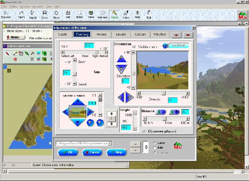
Mountain 3D is a virtual landscape generator
based on fractal computation. It allows creation and
modifications of the landscape in 3 dimensions.
The result includes trees, rivers, sky, and reflection on the water.
The picture can be seen under the angle and light adjusted by the user.
This program offers infinite creating possibilities, b
by means of a crowd of options and parameters.
Those lanscapes made by Mountain 3D represents wild nature.
The result is a picture file in BMP or JPEG format.
the last version of mountain 3D can generate videos at AVI or MPEG format, simulating fly over the landscape along a circle path or a 3D Bezier curve open or closed defined precisely in a new user interface.
After creation, the landscapes can be distorted by raising or digging around a point or a line. Rivers and their valleys can be placed. Cliffs an terraces can be added. It is possible to smooth portions or get rough portions of the landscape. Those modifications are operated via a graphic editor part of the application. It represent the geographical map an section of the landscape.
Several landscapes can be represented and seen
under different angles. The observer position, the light, and the
ground look can be changed. The sea level, grass, rock and snow
levels can be easily controlled. Different kinds of trees can be
generated in 3D fractals.
Colors and contrast can also be changed. The sky is created using
a fractal method (plasma) an the weather (sun, mist, reflection
in water) can be simulated.
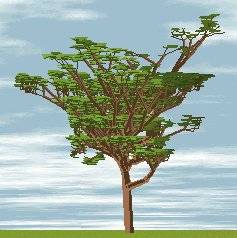 The trees generation method , also based on fractals, is new:
It has been entirely designed by the author, based on natural growth.
An example is given here.
The trees generation method , also based on fractals, is new:
It has been entirely designed by the author, based on natural growth.
An example is given here.
Real landscapes can be loaded in Mountain 3D by means of BMP bitmap
files representing a map with elevations coded with colors.
For example, you can see here the result of importation of the "Mont Blanc" mountain.
DEM files (Digital Elevation Model) describing 3D relief for real landscapes can also be imported.
This application runs on PC under Windows 95, 98, NT and XP and have a complete online help file.
Mountain 3D has been reviewed on Zdnet Library. Here is the text review : "Mountain 3D allows you to generate and modify landscapes that include mountains, trees, rivers, skies, cliffs, terraces, and reflections. You can display the results using desired angles, light conditions, and colors. Random generation, based on fractal specifications, lets you have numerous landscape types, with various profiles and elevations. You can also load real landscapes using bitmap files that represent a map with color-coded elevations. (A real landscape example is included). Save the output as standard, editable .bmp files, and print them with titles and comments. Despite a few rough edges in the interface, Mountain 3D might be worth a look if you enjoy making mountains out of thin air."

![]()
A shareware is a software that the user can try free before purchasing it
This software is not a "demoware". On the contrary it has full functionalities. The principle of shareware is very simple. The user can download this software and try it freely as much as he want during a try period of one month (30 days). If the program meets his needs, and if he want to use it frequently, he must register it, by paying the registration fee of $14 to the author. The fasted method is ONLINE REGISTRATION via a SECURE SERVER PaYpal using a credit card (click on the PaYpal icon above).
The registered version will give to the user important advantages, such as:
- expanded and improved features (definition and size of image, number of images generated),
- information about the new versions,
- free use for further versions,
- free technical support by email or telephone.
Registration is very simple: after paying online via PaYpal - $14 - , or an international money order through the post office, you will receive from the author by e-mail, a personal key number. This license number allows your program to be used without any limitation
![]()
|
Vidéos. |
Author: Corentin JAIN - email
© C.Jain 1996-2005


)
)
)
)